

Precision As-Built LiDAR Measuring & 360° Virtual Tours in Nicaragua
Eliminate guesswork, tape-measure errors, and costly construction rework. We capture existing site conditions with high-density laser scanning, delivering CAD spatial files ready for your architect, contractor, or overseas design team.
Path to Precision As-Builts & Digital Twins
From 360° LiDAR scanning on day one to verified AutoCAD base plans and interactive digital twins — every step is handled with rigorous precision.
360° LiDAR Site Scan
Our certified technician captures hundreds of thousands of laser pulses per second, generating a millimeter-accurate 3D digital twin of your property — far superior to traditional manual tape measures.
2D CAD Spatial Layout
We process raw spatial scans into clean AutoCAD (DXF/DWG) layouts, vector PDF floor plans with exact room dimensions, ceiling heights, wall thicknesses, and window/door schedules.
Architectural As-Built Base
Architects, interior designers, and structural engineers overlay proposed modifications directly onto the verified baseline data, eliminating spatial conflicts before demolition or construction begins.
Interactive 3D Walkthrough
Your team and overseas clients explore the property virtually from anywhere in the world. Includes on-screen laser measuring tools, floor plan navigation, and secure passcode protection.
Proven Track Record Across Nicaragua
We have helped homeowners, architects, and commercial tenants across Nicaragua capture existing conditions with millimeter accuracy.
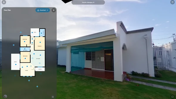
D-40 Residencial Cedro Galán
Managua, Nicaragua
Featured open sample showcasing full 360° LiDAR scanning, on-screen laser measuring tools, and downloadable metric floor plans.
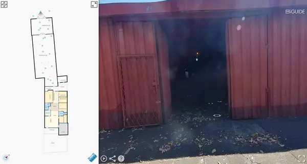
Hogar Propio Bodega
Managua, Nicaragua
Commercial storage and logistics facility spatial scan documenting high-bay storage heights, structural columns, and loading bay clearances.
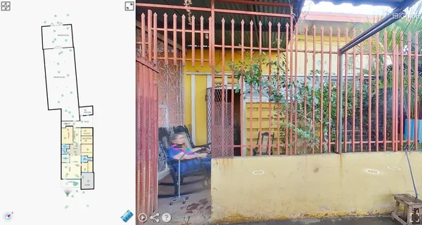
Hogar Propio Casa
Managua, Nicaragua
Private residential estate walkthrough documenting multi-level floor layout, pool terrace, and structural finishes for overseas ownership review.
Why Accurate As-Builts Are Crucial for Nicaraguan Projects
Renovating historic colonial buildings in Granada, modern residences in Managua, or hillside vacation villas in San Juan del Sur presents serious spatial challenges. Non-parallel walls, uneven ground elevations, and unrecorded structural modifications cause huge budget overruns when drawings are based on manual tape measurements.
We use high-precision 360° LiDAR Scanners mounted on tripods. The system captures every wall, partition, beam height, door opening, and structural column with millimeter-level accuracy. We turn these point clouds into AutoCAD (.DWG) spatial baselines and interactive digital twins.
Whether you are an overseas property owner supervising a remodel from North America or a local Nicaraguan architect preparing construction sets, our drawings give your team the undeniable spatial foundation needed to build right the first time.
"Overseas investors and local developers cannot afford assumed measurements. A 360° LiDAR digital twin eliminates spatial doubt and gives all stakeholders remote verification."
— Edward Vega, Spatial Director • Canadian Blueprint Partner
What to Send Us for a Fixed Quote
To receive an upfront fixed proposal for your as-built measuring or 360° virtual tour, please share these details:
Property Location
The city, neighborhood, or department in Nicaragua (e.g. Managua, Granada, San Juan del Sur, Tola, León).
Square Footage / Meters
A rough estimate of the floor area or land plot you need scanned and documented.
Required Deliverables
Tell us whether you need 2D AutoCAD (DXF/DWG), dimensional PDF floor plans, 3D point cloud, or 360° interactive virtual walkthrough.
Intended Project Use
Renovation planning, real estate marketing, remote owner verification, or contractor tender documentation.
Transparent Pricing Baseline
Clear upfront fixed rates for laser scanning and spatial documentation across Nicaragua.
Starts at $180
Ideal for homes, apartments, and villas up to 2,000 sq ft. Includes full 360° LiDAR scan, interactive virtual tour, and vector PDF floor plan.
- Interactive 360° Virtual Walkthrough
- Laser Floor Plan with Room Dimensions
- Online Cloud Hosting Included
Starts at $350
For retail spaces, restaurants, office suites, and warehouses. Includes structural height documentation, column spacing, and CAD export.
- High-Bay Ceiling & Clear Height Checks
- 2D AutoCAD (.DWG/.DXF) Base Layer
- Private Passcode Gatekeeper
Fixed-Fee Contract
Comprehensive architectural survey packages for major renovations, multi-building hospitality compounds, and engineering teams.
- Complete Layered AutoCAD Deliverable
- High-Density Point Cloud (.XYZ / .LAS)
- Priority Fast-Track Processing
Frequently Asked Questions
Answers to common questions regarding LiDAR scanning, CAD deliverables, and booking in Nicaragua.
What scanning technology do you use in Nicaragua?
We use PLANIX Pro spatial imaging systems featuring precision LiDAR time-of-flight laser sensors and high-resolution spherical optics. The hardware captures interior geometry with less than 0.5% measurement uncertainty, verified to Canadian Blueprint standards.
How long does an on-site scan take?
For typical residential properties (1,500–3,000 sq ft), on-site capture takes between 45 to 90 minutes. Commercial facilities or complex multi-level estates in San Juan del Sur take approximately 2 to 4 hours. No disruptive tape measuring or furniture moving is required.
In what file formats do you deliver the as-builts?
Standard deliverables include interactive 360° virtual tours, high-resolution vector PDF floor plans with both Metric and Imperial dimensions, and layered AutoCAD (.DWG / .DXF) spatial base plans. 3D point cloud files are also available for BIM/Revit workflows.
Do you travel outside of Managua to San Juan del Sur and Granada?
Yes! We regularly travel throughout western and southern Nicaragua, including Managua, Granada, Masaya, San Juan del Sur, Rivas, Tola (Emerald Coast / Popoyo / Guacalito), and León. We provide consolidated trip quotes for regional projects.
Can overseas owners and investors keep tours private?
Absolutely. Client confidential projects are protected by our edge gatekeeper. Only authorized stakeholders with your project access code can open the 360° walkthrough. Tours are streamed directly from private Cloudflare R2 storage without third-party ad tracking.
Get an As-Built & 360° Tour Proposal
Ready to schedule a scan or request spatial CAD drawings? Send us your project details below for an upfront fixed-fee proposal.
Active Service Regions
Managua • Granada • San Juan del Sur • Rivas & Tola • León • Carazo